Adding New Data Sources
GeoMedia SDI Portal lets you add new data sources of different types and then work with spatial data served by these data sources (services). For connecting to services, GeoMedia SDI Portal offers a set of connectors that lets you consume data and functionality delivered by the services. Your administrator can predefine connection to a service, but you can modify them. Connecting to the services is completely asynchronous, meaning that you never need to wait for a response from all requested services. In addition, you can stop the call and see only the data that was provided by other services. This approach increases performance and makes the application more reliable – the Web application never hangs while waiting for an unresponsive service.
GeoMedia SDI Portal offers connectors for the following services:
Service Name |
Description |
|---|---|
WMS (Web Map Service) |
For consuming map data delivered by WMS services and presenting it in a map window |
WMTS (Web Map Tile Service) |
For consuming map data delivered by WMTS services (raster tiles) and presenting it in a map window |
WFS (Web Feature Service) |
For consuming vector data/queries delivered by WFS services and presenting the result in a map window or data window |
WFS-G (Web Feature Service - Gazetteer) /Nomenclator |
For consuming vector data (gazetteer data) delivered by WFS-G services and presenting it in a map window (as pins) or on list of found objects |
CSW (Catalog Service) |
Provides an interface to discover, browse, and query metadata about data, services, and other potential resources |
WCTS/WPS–CT (Web Coordinate Transformation System) |
Performs transformation of GML data from one coordinate system to another |
Google Maps |
For consuming map data delivered by the Google Maps service |
Microsoft Bing |
For consuming raster map data delivered by the Microsoft Bing service |
OpenLS |
For consuming data delivered by OpenLS services and presenting it in a map window (as pins) or on list of found objects |
LUWS |
For consuming data delivered by LUWS services and presenting it in a map window |
GeoRSS |
For consuming data delivered by GeoRSS services and presenting it in a map window |
Map Publisher |
For consuming map data and vector data, queries, and analysis delivered by a service using the MPS (Map Publisher Service) |
EGIS (Enterprise GIS) |
For consuming map data and vector data, queries, analysis delivered by a service using the EGIS configuration |
Personal (Personal Storage Service - PSS) |
For utilizing map and vector data delivered by a user-defined service |
Printing |
For using external print services |
IWS |
For consuming raster data delivered by Erdas IWS (Image Web Service) service |
You access all tools for manage data sources in the Tools tab.
![]() The MapPublisher service (MPS) can contain several applications, so it is needed to set an application from which maps and data will be consumed. To select an application available for the MPS service, use the Application drop-down list in the Data Source dialog box.
The MapPublisher service (MPS) can contain several applications, so it is needed to set an application from which maps and data will be consumed. To select an application available for the MPS service, use the Application drop-down list in the Data Source dialog box.
![]() To be able to consume ERDAS IWS raster data in SDI Portal, the ERDAS ECW Plug-in must be installed for the client machine. This plug-in adds high-performance streaming of both ECW and JP2 geospatial aerial and satellite imagery over the internet using the ECW Protocol (ECWP) from ERDAS APOLLO Essentials Image Web Server. The Microsoft Internet Explorer, Mozilla Firefox, and Google Chrome browsers are supported. To download the ECW Plug-in go to the following Web page: http://www.erdas.com/products/ecw/ECWPlugins/Downloads.aspx.
To be able to consume ERDAS IWS raster data in SDI Portal, the ERDAS ECW Plug-in must be installed for the client machine. This plug-in adds high-performance streaming of both ECW and JP2 geospatial aerial and satellite imagery over the internet using the ECW Protocol (ECWP) from ERDAS APOLLO Essentials Image Web Server. The Microsoft Internet Explorer, Mozilla Firefox, and Google Chrome browsers are supported. To download the ECW Plug-in go to the following Web page: http://www.erdas.com/products/ecw/ECWPlugins/Downloads.aspx.
Tools
Show data sources ![]() shows all the services currently connected to the GeoMedia SDI Portal and available to you. The URL to the service and the type of source are presented in the window with defined data sources information, such as the data source name.
shows all the services currently connected to the GeoMedia SDI Portal and available to you. The URL to the service and the type of source are presented in the window with defined data sources information, such as the data source name.
For every data source that is displayed in the Data Sources window, you can use a right-click menu to remove the selected data source from GeoMedia SDI Portal. Removing a data source causes the corresponding layers from the map window and entries from the map content to disappear automatically.
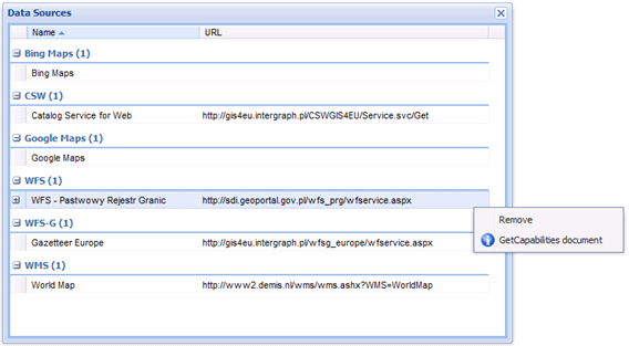
![]() For sources such as WFS (Web Feature Service), WMS (Web Map Service), and CSW (Catalog Service for Web), GetCapabilities document is available in the right-click menu. For the selected service, you can read the GetCapabilities document in a new window. Also, for WFS services you can read the Describe Feature Type document for every feature class served by a given service. Expand the tree and select a specific feature class.
For sources such as WFS (Web Feature Service), WMS (Web Map Service), and CSW (Catalog Service for Web), GetCapabilities document is available in the right-click menu. For the selected service, you can read the GetCapabilities document in a new window. Also, for WFS services you can read the Describe Feature Type document for every feature class served by a given service. Expand the tree and select a specific feature class.
To add a new data source:
- Click Define a data source
 .
. A New Data Source window opens, and a list with connectors to the services displays on the left side of New Data Source.
- Select a connector. Type a link to the service in the URL field. You can further define connection parameters using available controls for the selected type of service.
- If a service requires authorization, click
 , select an appropriate authorization method, and, if needed, type a username and password to register a service.
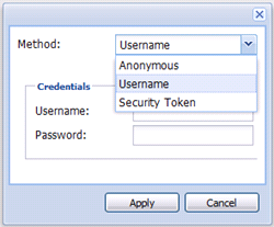
 The appearance and functionality of the fields in the New Data Source form may vary depending on the connector.
Registering services such as WMS results in automatically displaying data (layers) from those services in the map window. You manually display other types of services (data sources) layers in the map window using the Display maps or Displays map or queries tools.
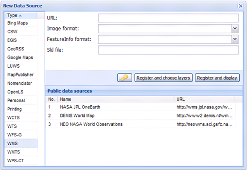
- Your administrator can prepare a list of services and links to the services available to you. To connect to the service from the list, select the service. All required fields specifying the connection parameters will be populated automatically.
| Top of Page |